This is my first Trip Report for the 2015 UltraPedestrian
Wilderness Challenge. The UPWC is variably described as an adventure blogging contest and “a forum…to connect, share ideas, exchange trail beta, and propagate
misinformation to mislead their competitors”.
One or more of the following routes must be completed,unsupported, and documented between by December 2015:
One or more of the following routes must be completed,unsupported, and documented between by December 2015:
- Chinook Pass/Eastside Trail/Laughingwater Loop on the east side of Mt. Rainier National Park
- Enchanted Valley/Graves Creek Loop through the Olympic National Park
- Easy Pass to Diablo Lake through the North Cascades Wilderness Area
In addition to unsupported travels through the wilderness, I
am navigating the multi-media technology unsupported, just blundering along
through the alternative space-time continuum of unsupported platform warnings, frozen upload screens, and mistaken password identity crises. For better or worse, I credit UPWC for provoking me to share my trail running adventures.
The context for the technophobe angle of this blog is provided
in my June 2015 post titled “The Challenge”.
THE TAPER
In preparation for the Chinook Pass Loop, I spent two days technology-tapering
with a Washington Trails Association crew on Mt. Rainier’s Summerland Trail.
The only power tool I brought along was the camera on my iPhone. No
chance of picking up a stray wireless signal out here, but I switched the iPhone
settings to “pioneer mode” just in case.
TRAIL RUN MODE
While
preparing for this adventure, I imagined that I would spend more time in this Trip
Report answering questions such as:
- What kind of 'food' do I eat for a 32-mile trail run? Dang, I left that PB&J simmering inside my car…Will I have enough food today? Well…at least I didn’t leave the entire jar of peanut butter cooking on the dashboard…Daaang, I sure hope this route doesn’t take me longer than 10 hours...
- Wait, how old is that map? Hmmm, good question…I wonder if any of these trails have been rerouted since 1971?
- Was there enough water? Yes, but many dry creek beds too, in late June.
- How do I filter my drinking water? I don’t! I’m perfectly happy using iodine tablets. I packed 2 liters of tapwater (in an old Camelbak M.U.L.E.), plus a 12-ounce hand-held bottle (Amphipod), and treated 2 liters along the way using iodine tablets.
- Did I see any wildlife?
Seven
skittish gossamer wing blues, one alight,
Two
shy whooping grouse, none in sight,
One
pileated woodpecker, startled to flight,
And tattered paper wasp nests, but
Not one insect bite.

 | |||||||
| HIGHLY RECOMMENDED: DEET-free Kids Herbal Armor (NOT the NIOSH guide!) |
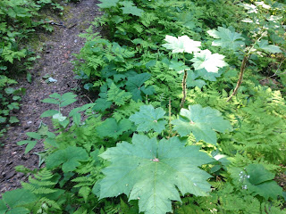
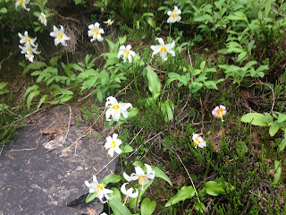
Instead, I will obsess about the GPS. And the wildflowers. The wildflowers were breathtaking.
I started from the Naches Peak Loop
trailhead at 0701 Sunday morning on
June 28 with a brand new Suunto
Ambit3 S GPS watch and no instruction
manual.
trailhead at 0701 Sunday morning on
June 28 with a brand new Suunto
Ambit3 S GPS watch and no instruction
manual.
Thirty-two miles, 10,000 feet of vertical elevation gain, counter-clockwise.
START/STOP clearly labeled on the GPS watch; what else could I possibly need
to know?
START/STOP clearly labeled on the GPS watch; what else could I possibly need
to know?
Along the way, I could not help but notice that the watch display emphasizes my running
pace, which is informative while I'm in motion, but you can practically
see the zeroes from outer space while I’m photo-documenting my progress:
0'00/mi.
How annoying....
How annoying....
Still, you can see that it wasn’t annoying enough for me to experiment with the buttons…as recently as this scene past Mile 23:
I’m pretty sure the START/STOP button is the WRONG button
for reprioritizing the display so…
(….monkeys with
typewriters…)
Yay, seven fifteen! That is MUCH better....instant gratification....except for the battery status bar at the bottom, which doesn't look promising.....But how about these wildflowers? And the deer ferns, and devil's club, and waterfalls and...oops, don't forget to keep moving...

Anyway, the watch worked GREAT for about 8 ½ hours. It would
be perfect if I wasn’t such a straggler. Fortunately, I recognized impending doom and booted up my Timex before the Suunto drifted off
to sleep around 1525, on my approach to Dewey Lake.
 Note
to self: portable charger
 for the next trip. And don’t leave
the charging cable on
the dashboard....with your peanut butter sandwich...
Now that I'm no longer able to record my route with GPS, I need to photodocument my route around the east side of Naches Peak....
 | |
| Trail junction at the south | end of the Naches Peak Loop. |
 |
| PCT descending north toward Chinook Pass behind me. |
shortcut route to Tipsoo!
Follow the PCT
instead!
 |
| "Like" |
 |
| Clouding over and sprinkling now. |
 |
| Pedestrian overpass and park entrance at Chinook Pass. |
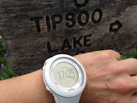
....17:05 on the Suunto...DO follow THIS sign to Tipsoo....
Did I mention the wildflowers????
Tipsoo in view, oh joy!
Last but not least, my dance around the Naches Peak Loop trailhead, where I started out at 7:01 this morning:
Here is the final score:
Suunto at 24.90 mi: 7:48' 18
minus Timex: -0:00' 15.30
plus finish line: +2:26' 54
eq. total run time: 10:13' 57
Including chatting with all the Parking Lot Hikers waiting to cross the suspension bridge to the Grove.
Until I figure out how to export the file, here is a screen shot of the first 26 miles:
THE AFTERMATH
Not now, Cat, I'm busy planning my next big Guilt Trip!


No comments:
Post a Comment